
RESOLVING THE LEDGER
RESOLVING THE LEDGER
Only one outlet has reported this event so far — you're reading it below, credited to its source. AIPROPX is tracking the web for more coverage; as additional outlets confirm it, this becomes a full multi-source story automatically.
By AIPROPX Editorial Desk · Published · Updated
One outlet is reporting this so far. AIPROPX is tracking it and will gather every additional source as it develops — the full multi-source comparison appears automatically once a second outlet confirms it.
Researchers have found that the amount of green space and shade in a neighborhood can significantly shape temperatures. On average, neighborhoods with more trees and green space — instead of impermeable surfaces like pavement — can run anywhere from 1 to 7 degrees Fahrenheit cooler. The phenomenon, which has been well studied in major urban cities, is called the “heat island effect.” But researchers have done far less work examining how those trends play out in more rural parts of the country.
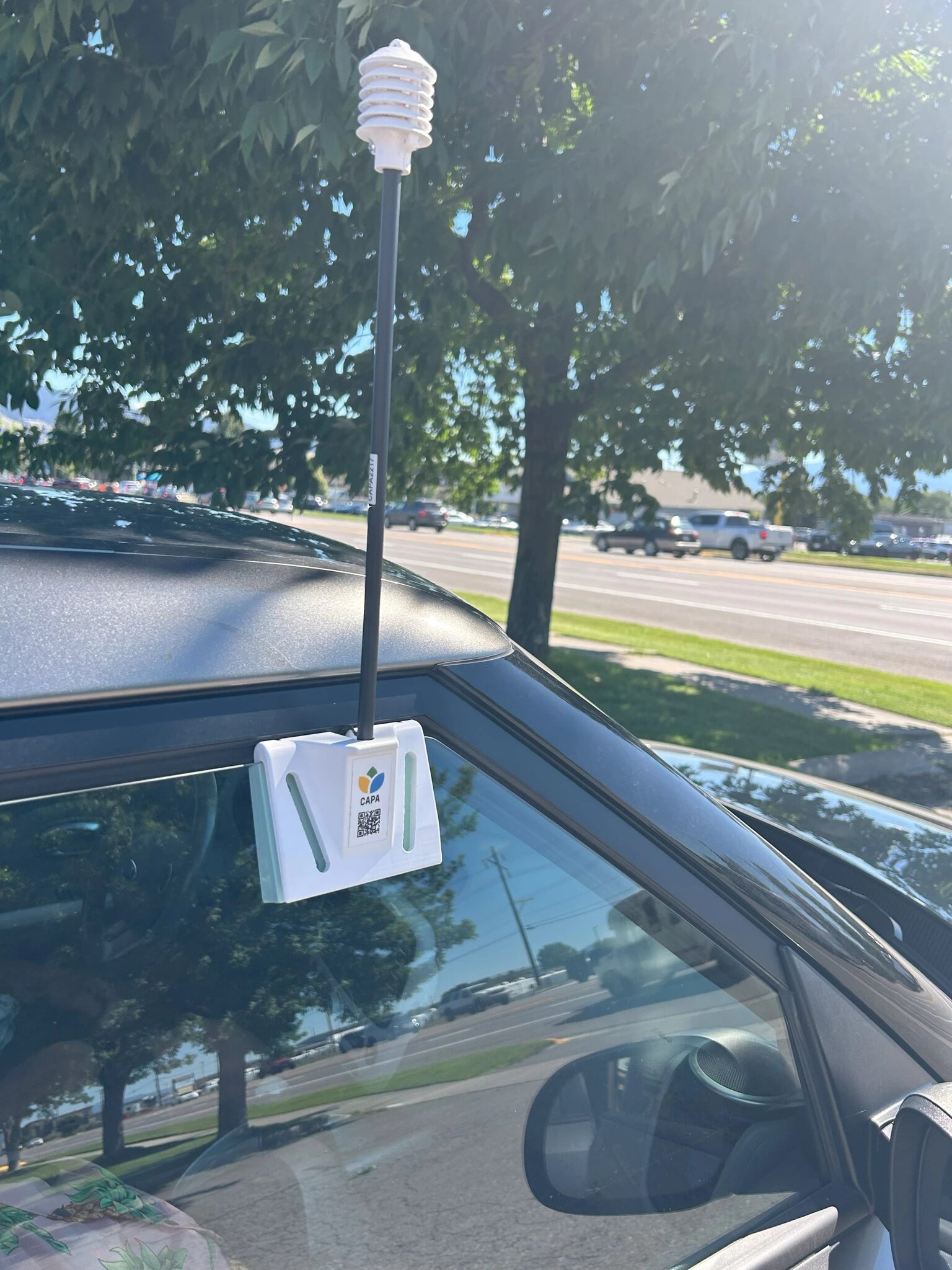
Missoula, Montana, is helping fill that gap. In 2024, Climate Smart Missoula, a local nonprofit, teamed up with the city and county of Missoula and secured federal funding for a heat mapping initiative. Last summer, teams of volunteers drove countywide transects with sensors recording second-by-second measurements of temperature and humidity. Then analysts with the climate adaptation consulting firm CAPA Strategies turned the data into a now-publicly available heat map for the county . It’s the first of its kind for the state and this region of the Rockies. (Cities in Wyoming, North Dakota, and South Dakota also do not have heat maps.)
A humidity and heat sensor attached to a car window collect data to create Missoula County’s heat map. Ellis Juhlin
The research is especially important because Missoula has historically had warm, dry summers. Temperatures in the western Montana county climb into the 80s, with occasional stretches in the 90s, before cooling off sharply after sunset. But that pattern has shifted in recent years, with hotter summers and warmer nights. The area is already experiencing more days with temperatures above 90 degrees F each year. The county’s average annual temperature is projected to increase by 4 to 5 degrees F by 2050 .
The change poses particular challenges for places like Missoula, where homes, buildings, and other public infrastructure were built for cooler climates. Montana has one of the lowest rates of residential air conditioning in the country. When the heat builds, Montanans don’t have the same infrastructure as Arizonans or Texans to keep cool.
The researchers found that temperatures can vary by nearly 20 degrees across Missoula County depending on the prevalence of shade from trees and other green spaces. Susan Teitelman, with Climate Smart Missoula, said their findings mirror heat maps in other larger cities across the country.
“What we’re seeing in Missoula mimics larger cities like New York and Boston,” she said. “You see the same thing happening everywhere: Poorer, hotter neighborhoods have fewer trees; wealthier, greener neighborhoods have lower temperatures.”
Alli Kane, the county’s climate action program coordinator, said some of the results weren’t surprising. Neighborhoods like the University District or the Rattlesnake, where large, mature trees provide shade, were significantly cooler than the Northside or Westside.
“Places where we anticipated we would have heat islands were downtown Missoula, around Southgate Mall, those areas that are more urban and more built up,” Kane said.
But there were surprises, too, including how dry, brown open lands, like an empty lot in town, acted as heat islands, according to Kane. These unmanaged and undeveloped spaces tend to be a magnet for invasive species that quickly adapt to hot and dry conditions. When they’re left unwatered and not replaced with native species, they can act as heat islands, Kane said. The research showed heavily forested places like Seeley Lake and Evaro, a rural area north of the city center with dense trees, also held on to heat overnight.
“You’ll see, especially in the morning map, they are retaining heat from the day before because of that really dense canopy, and so that effect is resulting in some of our highest-recorded morning temperatures,” Kane said.
Agencies like the National Weather Service have consistently identified heat as the most deadly weather Americans experience. Research from the University of Montana published in 2024 found that for every 1 degree Celsius temperature increase, 911 calls increased correspondingly by 1 percent. Many of those calls came from rural areas with older, retired populations that are more susceptible to extreme heat.
Read Next
These psychedelic images reveal what your weather app isn’t telling you
Matt Simon
The city and county of Missoula and Climate Smart launched a campaign called Stay Cool Missoula to build community resilience for extreme heat and attempt to prevent those deaths. Teitelman with Climate Smart Missoula pointed out that it’s critical to prepare communities for what is coming.
“Extreme heat is dangerous,” she says. “It is impacting Missoula and Montana. It’s impacting northern climates, and it’s an issue of equity.”
Teitelman leads Climate Smart’s efforts to plant trees in lower-income neighborhoods where tree cover is sparse or nonexistent. Having access to the heat map has helped her target those planting efforts. The map has been put to use in other ways too, like conversations around the proposed data center in Bonner on the banks of the Blackfoot River. That project was ultimately canceled by the property manager. But Kane said being able to showcase just how much warmer that area is, due to the amount of land cleared for industrial use, will help inform the county on future regulations and decision-making.
Missoula was one of 11 communities — including New Orleans, Memphis, Buffalo, and Moab, among others — that NOAA funded as part of a nationwide effort to map heat islands in 2025. But the work almost didn’t happen.
Like many federally funded projects related to climate change, it was targeted by the Trump administration. Kane, Teitelman, and their other partners had been awarded the grant from the National Oceanic and Atmospheric Administration’s Center for Collaborative Heat Monitoring Program in 2024. The money was allocat...
Indexed and credited by AIPROPX. Originating outlet: Grist. Open at source →
An original, deterministic readout — composed only from the computed coverage facts on this page. No interpretation, no rating; figures only.
AIPROPX has consolidated 1 report from 1 outlet into a single canonical entry on “As Montana warms, Missoula’s first heat map reveals hidden hotspots.” Every covered outlet is based in Other.
The only timestamped report came from Grist (Aug 13, 2026, 08:30 UTC).
2 statements are carried by only one outlet within this set and are not echoed by the others.
Every figure above is a direct count of real published articles. AIPROPX indexes and compares the original reporting — it never rewrites, rates, or editorializes — and each publisher’s full article is always one click away.
Generated by AIPROPX from the source counts above. AIPROPX indexes and resolves coverage; the original publishers are credited and linked at origin in every report.
Coverage from 1 independent outlet across 1 region — each view opens on its own page.
AIPROPX — “As Montana warms, Missoula’s first heat map reveals hidden hotspots” · https://www.aipropx.com/story/e12709619bab6abbdcc3c66ae973225c
Other events being covered across multiple sources right now.
Extreme heat warning issued as UK braces for high temperatures
4 outletsStudents and staff welcomed back for first day of school in Douglas County
3 outletsThree US states to hold executions on same day for first time since 2010
1 outletsMap Shows Dollar Tree's Store Opening Spree as Rivals Shut Locations
28 outletsLeavitt to leave as White House press secretary
24 outletsNASA holds viewing party for Perseids meteor shower